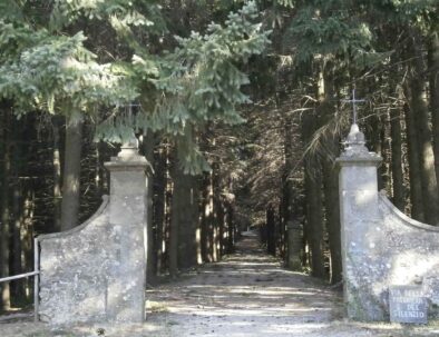
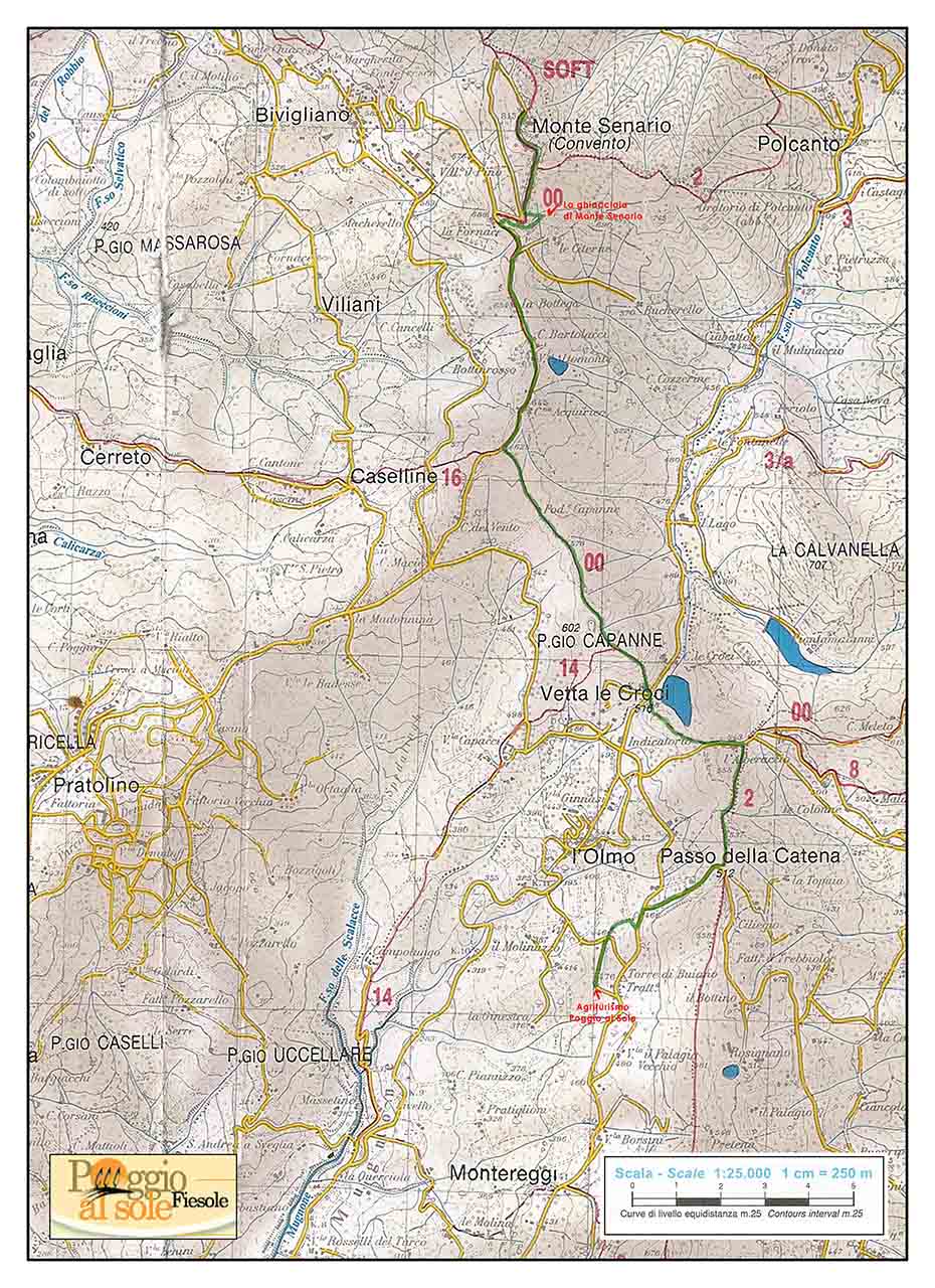
Monte Senario

Itinerary 2

"On the foothills of the Apennines, on top of God’s mountain" Poggio al Sole - Montesenario - Poggio al Sole

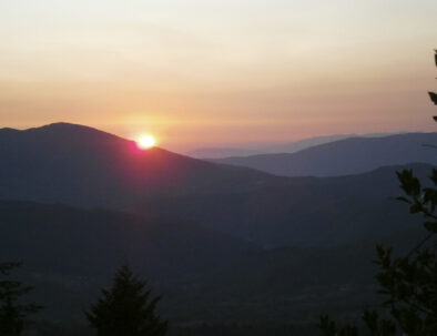
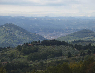
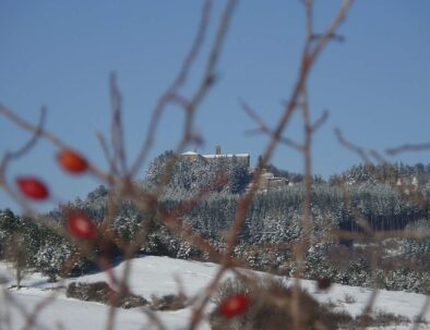
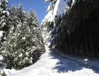
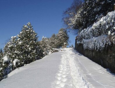
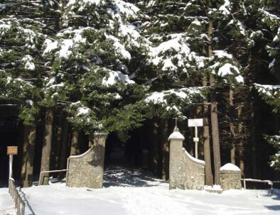
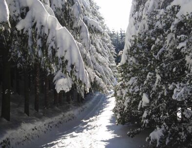
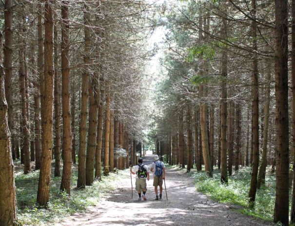
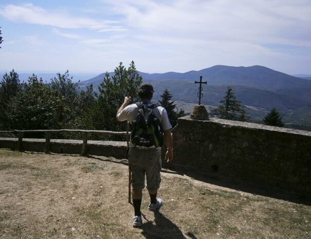
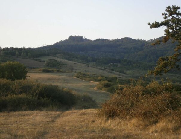
This is a return trail. The first segment mostly climbs to reach the top of Montesenario and its ancient convent, which silently watches over the valley and the fantastic view of Mugello, a large part of the Tuscan Apennines and the countryside of Fiesole and Florence. The building stands out from the surrounding countryside on top of the mountain, all around a dense forest of conifers. The landscape is mystic and charming, and few visitors can resist from ascending the top. It’s a long way, but the effort will surely pay off.

Distance: 14 km – 8,69 miles (return trip)
Elevation grade: 532 m (446 m one way).
Difficulty: average (to go)-easy (way back).
Estimated time: 4-5 hours (return trip). Allow at least another 30 minutes to visit the monastery.
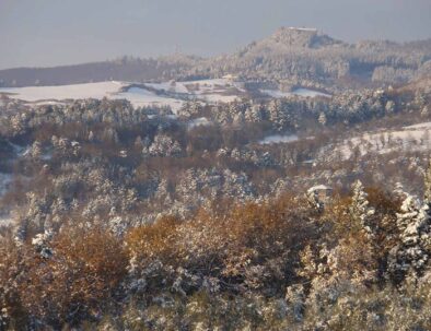
Suggested time of the year: all year round (there may be muddy segments during rainy days. In every season consider a lower temperature (at least 3°C) in Montesenario than that at the Agriturismo Poggio Al Sole, and the possibility of strong, cold winds, particularly in winter.)
Interest: landscape-history.


Webpages to know more:
http://www.montesenario.net
http://www.regione.toscana.it/regione/export/RT/sitoRT/Contenuti/link/banchedatinascoste/visualizza_asset.html_659502543.html
http://www.servidimaria.org

The first segment of the footpath is similar to Itinerary 1, which you find below.


Leave the entrance of the farmhouse Poggio al Sole on your right and proceed for about 500 m along via Torre di Buiano, an ancient place-name presumably of Longobard origin, already referred to as corticella di Bujana in some documents dating from 890. Ignore the two streets crossing it – one on your left descending and the other climbing on the right- and drive along the hay barn with annexed farm house, Podere l’Acquinvoglino, until you cross Via dell’Acquinvoglino, then turn right in opposite direction to the houses. It is said that the name of this ancient road comes from the Latin word acqua bulliens (gurgling water)due to the presence of numerous springs (the majority of which are now dried up)known since the Roman age and used to supply the aqueduct of Fiesole and the XVI century-aqueduct of Florence, which can be still seen at the bottom of the valley.
Once you get to Via dei Bosconi (S.P.54), turn left and then take via Catena, which is immediately on the opposite site, toward Monteloro. After 500 m you will get to Passo della Catena (515 m.). Take trail n. 2 on the left, which is marked with a white and red stripe, toward Alberaccio.

From here, the footpath leaves Itinerary 1 and crosses with the The Renaissance ring (name of the trail A. R.), a 170 km (105,57 miles) walk which winds through the hills surrounding Florence, which centre is ideally represented by the Brunelleschi Dome.
On your right you can see from a distance the Sanctuary Madonna del Sasso, immersed in a thick wood of chestnut-trees, in the heart of the Protected Natural Area of “Poggio Ripaghera”. In this segment, the trail borders the northern part of Fiesole municipality, which roughly corresponds to the limit of the typical Fiesole landscape, marked by the cultivation of olive groves.

We leave the olive trees behind and proceed for 500 m until the little village of Alberaccio, where a graveyard stands to commemorate the murder of a partisan; then onward across the province road and along the ridge of Olmo. Here we take trail n. 00 (marked in red and white) going to Montesenario.

The landscape here is typically pre-Apennine, with a magnificent view over the entire valley of ravine Mugnone, a real natural amphitheatre closed on one side by the hills of Montereggi and Poggio Pratone, and on the other side by Montemorello and the hills of
Pian di San Bartolo, Basciano and Pratolino. The valley is spread with rural houses, fields divided geometrically and cultivations, where vineyards and olive groves alternate with woods. The presence of men and their work is immediately perceivable, but an ancient harmony with the environment seems to pervade the space, a multicolor mosaic made up of green, yellow and brown nuances, according to the season.
The mountains of Montececeri and Monterinaldi rise in the background, breaking this idyllic pattern and forming a canyon which offers protection to the city of Florence.

Behind these mountains appears like a magic Florence Cathedral, the final goal and the human heart of this territory. After having filled our eyes with this magnificent view, it’s now time to get back to the trail. There is still a long way to the top, but there are more and more view points to enjoy along the path. Below on the right is an artificial lake hidden by roses and wild blackthorns. The lake precedes the crossroads of Vetta le Croci ( which name reminds of the crosses used for burials after the battle of 406 a.c. between the Roman troops led by the German general Flavio Stilicone and the Ostrogoths led by Radagasio) and Via Faentina (be careful while crossing it, as there are many trucks). We leave the road behind and proceed on the trail, which climbs along a fence, then, after a turn on the left, it gradually becomes steeper, running alongside a string of maple trees, wild cherry trees and pine trees, until it reaches the thick forest of Poggio Capanne (602 m). On your right, opposite the valley, some calcareous hills shaped by the erosion standagainst the Apennines and the north of Italy. Keeping the right we walk around Poggio Capanne, until the little descending trail comes within sight of large prairies, often swept by the wind. The presence of wind is witnessed by a rural house, named La Casa del Vento, once owned by Fattoria dell’Olmo, an ancient and traditional example of centralized economic-territorial organization. On the left side the wonderful view of Florence as company, whereas on the right side, beyond Mugello, rise the Apennines peaks.
Here the typical landscape of Florentine hills and metayage are replaced by an open, spacious countryside, where pasture lands dominate, with cattles (of the charolaise, limousine and Italian red spotted species), about 60 head of cattle in total. This is not a traditional activity of this area, nevertheless it recalls the time when each farmer used to have at least a couple of cows to help them with agricultural works, and in the entire valley, the animals were a signal for the presence of farmers of the opposite face.
Now the trail proceeds for about 1 km (0,62 miles), gradually climbing, until it crosses the tarred road, in proximity of a cross which reminds of the Seven Saints, founders of the convent of Montesenario and the religious order of the Servi di Maria. According to tradition, on 31st May 1234 while they were climbing the mountain to withdraw in their eremitic life, the Saints stopped here for a rest. We turn right and carry along the street for about 1.2 km (0,74 miles), until we meet trail n. 63, but we ignore this trail and walk on toward trail n. 65 (the Renaissance Ring), which leads us, after 200 m., to a weird building in the shape of dome: la Ghiacciaia di Montesenario. This building, built between 1842 and 1844, belonged to the order of Servi di Maria, and was used as storage for the ice taken from the artificial lakes situated in the surroundings. In summer, the ice blocks were taken to Florence by means of drums. We leave the building on our right we take a steep but short trail which leads to a square place opposite the Via del Silenzio (or Via Matris). Walking along this street you can admire seven tabernacles, representing the Seven Pains of the life of Mary. The street reaches the convent through the ancient road once accessible only by mule, before the tarred road was built in 1964. The street becomes steeper and steeper, winding through a thick wood of black pine trees, white firs, maple and chestnut trees, where the sunlight can hardly filter through. The forest heritage here is remarkable, mainly represented by white firs, the result of a recent repopulation program, even if the presence of this plant is much more ancient (beginning of the XVII century). The monks who settled here were the first to introduce the white firs, so much loved by the Vallombrosian Benedictines, who considered this plant as the closest to the spirituality of religious orders. Actually the word may derive from the Latin Ab (from), and eo (to go), assuming the meaning of “I am going away”. Therefore, the fir symbolizes the passage from down to above, from earth to heaven, and God.
After passing the little church of San Martino, built in 1946 on the foundations of an ancient building, we start the final steep segment, which ends in the square place opposite the convent surrounded by hollies: in winter it is sometimes possible to admire the red drupes creating quite a contrast with the white of snow. Finally we can put down the rucksack and have a little tour of the convent, visit the church and the little cellars embedded in the rock, where the founders of the convent lived in meditation. And we can also enjoy a glass of “Gemma d’Abeto”, a spirit produced and sold by the monks, which comes from the infusion of fir gems and other medicinal plants. The characteristic yellow color is given by saffron. The silence makes a good company as we watch in awe the magnificent view of Fiesole and Florence to the south, Carza and Carzola to the west, the Apennines to the north and the faraway Apuan alps.
Tradition has it that the convent of Montesenario was founded by the Seven Saints while searching for a place where to withdraw in eremitic life. But the origin of the building is probably older. Its strategic position, dominating 360° over the territory, allowed the control of the ancient communication roads, therefore it is supposed that the convent made part of an important castle of the Florentine territory, the Castle of Monteronzoli, mentioned in documents dating from the XI century. The castle was destroyed by the Florentine Republic during its expansion phase in the territory. But the origins of the convent seem to be even older than that, as proved by the immense territory which we face looking toward Florence and the half-moon shaped hills of Fiesole. In order to follow the footsteps of history, we need to take that trail going to Polcanto, which starts on the left of the final ascent (now a descent), and after a few meters, look among the trees and a building which partly hide the view. Still today, in the tradition, for people of Florence the Apennines begin here in Montesenario. This is the place that marks the border between the sweet hills, the valleys of Arno and the mountain chain running through central Italy. In getting here from Florence, a sense of mysticism wraps us. Leaving this feeling to reach the city is an ancient and deep call toward civilization.
Montesenario, the place of silence, of the cold wind “Tramontano”, represents the north of Fiesole, where snow covers firs and the sun sets behind the mountains. Just go to Fiesole one day and visit the archaeological area. Sit on the steps of the Roman Theatre or go to the Etruscan temple, then look up: Montesenario will appear above on the right. North, South, mountains, horizons, where the land touches the sky and they seem a whole… The Etruscan populations of Fiesole enjoyed a continuous view of this mountain from every building of the town, and the hills represented a sacred place for them.

The Etruscan word “Eiser” or “Aiser” probably meant “gods”. Hence the word “Senario” and Montesenario, the mountain sacred to Etruscan Gods.
Now the essence and magic of this place is self-evident, as well as its profound spirituality, where ancient and modern, men, God and nature, and man with himself, seem to co-exist in the eternal flow of time.


Itinerary and photos by Giovanni Crescioli: www.FiesoleBike.it